
For many operators, the core challenge has not changed: maintain an accurate position underwater, even when aiding is intermittent, degraded or unavailable. What has changed is the expectation placed on the navigation system. Today, it must support survey-grade data, vehicle control, autonomous decision-making, post-processing and easier integration—often on platforms where space, power and payload are tightly constrained.
Sonardyne’s journey not only reflects but has led that industry shift, starting with high-accuracy attitude and heading systems, through inertial navigation aided by acoustics, to the tightly integrated INS/DVL approach that became SPRINT-Nav, an industry-leading navigation solution.
Now, with an expanded SPRINT-Nav Family, based on a common architecture, SPRINT-Nav has been scaled across smaller ROVs, survey AUVs, work-class vehicles, towfish, and long-endurance autonomous platforms. It’s one family, with endless possibilities.
From Attitude to Navigation
“The early foundation was attitude and heading,” explains John Houlder, Senior Product Manager at Sonardyne. “Sonardyne’s Lodestar AHRS established the company’s capability in true north seeking inertial technology, with a heading that doesn’t depend on magnetic sensors. That’s critical around ferrous structures, wrecks, vessels, pipelines and offshore infrastructure, where it can become unreliable, precisely where accurate positioning matters most.
“The next step was to move from attitude into inertial navigation. SPRINT (standing for ‘Subsea Precision Reference Inertial Navigation Technology’) brought inertial navigation together with acoustic aiding, allowing vehicles to use Ultra-Short BaseLine (USBL) or Long BaseLine (LBL) updates to constrain drift and improve the continuity of the navigation solution. Our Syrinx Doppler velocity log (DVL) then added further capability, providing seabed-relative velocity as a core input to the navigation system.”
Integration & Calibration
“The major change came when those technologies were brought together,” explains Aidan Thorn, Business Development Manager, Marine Robotics. “By tightly coupling INS and DVL in a single instrument, SPRINT-Nav—now with more than 10 years of field proven performance—addressed one of the long-standing practical challenges in subsea navigation: field integration.”
SPRINT-Nav removed the time-consuming, weather-dependent work traditionally involved in setting up separate INS and DVL units; measuring lever arms, aligning systems, managing multiple interfaces and verifying performance offshore.
The DVL–INS alignment is now a factory calibration and validation process, supported by specialized test equipment, dedicated vessels, and a navigation engineering team. Sonardyne has optimized this process through the calibration of hundreds of SPRINT-Nav systems and characterized more than 1,000 inertial measurement units (IMUs).
This was moved into a controlled production and calibration process, with the DVL and INS mechanically, as well as computationally, aligned before delivery.
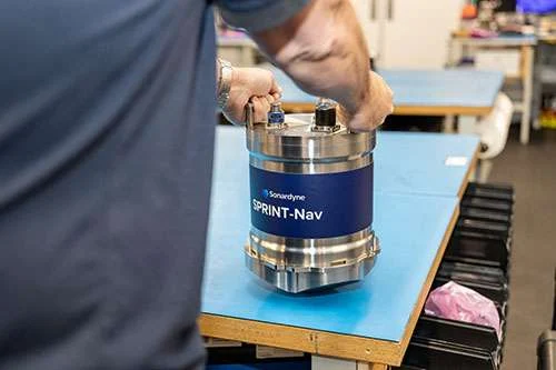
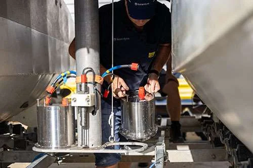
The SPRINT-Nav portfolio has been scaled across ROVs, AUVs, work-class vehicles, and long-endurance autonomous platforms. (Credit: Sonardyne)
Turning Multiple Inputs into a Trusted Position
But just as important is how all the inputs are combined, says John. “The navigation algorithms must decide how much confidence to place in each input, reject poor-quality aiding and continue to provide outputs with well described accuracy and high integrity when conditions change.
“Because our expert engineering team develop and integrate the INS, DVL and supporting software as one tightly coupled system, it optimizes how those inputs work together. DVL beam-level information can be used within the navigation solution, while external aiding sources, such as USBL, LBL and GNSS when available, can be filtered, weighted or rejected before they affect the result. This is the value of vertical integration. Family scalability: one architecture across vehicle classes.
“The Family is built on a common navigation architecture. This is increasingly important because the subsea vehicle market is no longer concentrated around one type of platform,” explains Aidan. “Observation-class ROVs are being asked to do more valuable inspection work.
“Towfish are carrying more capable payloads. Compact AUVs are being used for mapping, survey, and monitoring. Work-class ROVs still require rugged, high-performance navigation for construction and intervention. Larger autonomous platforms are pushing into longer-endurance and deepwater missions where free-inertial performance becomes more important.”
The expanded SPRINT-Nav Family addresses the full spectrum: SPRINT-Nav U for smaller ROVs, towfish, and AUVs; SPRINT-Nav M for mid-sized survey and inspection vehicles; SPRINT-Nav I and S for established survey and work-class ROV applications; and SPRINT-Nav X, F and FX for higher-performance and longer-endurance missions.
They’re operated across a common, modern web user interface, shared command and control, well-documented APIs and standard outputs for vehicle control and survey systems. That gives developers, fleet operators and survey teams a familiar integration and operating approach as they move between vehicle types and performance levels.
Extended Value Beyond the Instrument
The SPRINT-Nav family also reflects how navigation is broadening beyond position and velocity. SPRINT-Nav’s DVL can also operate in ADCP mode, allowing operators to collect current profile information alongside bottom-track velocity. This supports mission planning, stable tow, and better awareness of local operating conditions.
Post-processing extends that value. With Sonardyne’s Janus INS post-processing software, users can interrogate navigation performance after a mission, adjust settings, reject or re-weight aiding sources, and significantly improve outputs and thus survey deliverables.
SPRINT-Nav can also feed Sonardyne’s Fusion 2 positioning software for more complex subsea operations, including range aiding and SLAM calibration of sparse LBL arrays.
Where Subsea Navigation Goes Next
Looking ahead, subsea navigation will continue to draw on more diverse aiding, from acoustic positioning and GNSS to visual SLAM, mapping inputs, marker-based references, and water-track aiding.
The expanded SPRINT-Nav Family is at the heart of this ecosystem providing one navigation architecture, scaled across the subsea spectrum, with endless possibilities for the vehicles and missions it supports.