A Micro-AUV Set to Revolutionize Underwater Survey

A Micro-AUV Set to Revolutionize Underwater Survey
Obstacle avoidance enables navigating complex features without environmental damage. (Photo credit: Advanced Navigation)

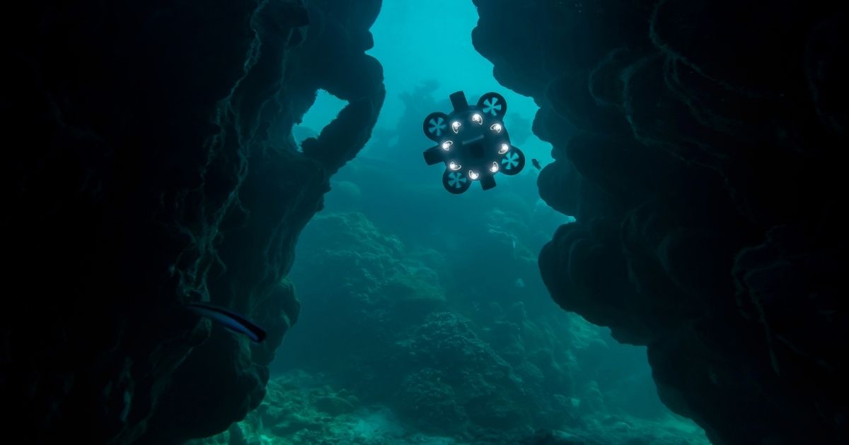
Underwater survey has traditionally been a highly specialized realm. Technologies have improved to bring levels of automation to it and, in some scenarios, very successfully.

This is particularly the case for large scale seabed surveys using side-scan sonar AUVs. Tethered ROVs have brought motion control and flexibility to shallower depths, however, with the limitations of requiring expert human pilots and an umbilical cord. These methods are logistically complex and very expensive and so require a better solution.

As an example of convergent technologies that have culminated in a step change within an industry, we can look at aerial drones. Their commercialization had expensive, specialist beginnings, however, now is accessible enough for many users to take advantage of. New applications that harness the efficiency, cost-effectiveness, and safety of this platform continue emerging.

‘’We have seen a revolution occur in the aerial drone market, where smaller, easy to use drones have opened new opportunities in applications previously restricted by cost. Hydrus intends to offer the same accessibility to the underwater world,’’ according to Xavier Orr, Advanced Navigation CEO.

UNDERWATER DRONE REVOLUTION

Advanced Navigation is heralding an underwater “drone revolution” with Hydrus—an affordable and easy-to-use micro-AUV.

Why is it revolutionary? Hydrus turns the traditional means of photographic survey in shallow and mid-depth water on its head. Prior to Hydrus, users would likely need to organize a survey months ahead. This may entail hiring contractors to provide and operate one or more appropriate ROVs. A surface vessel, usually large and fitted with appropriate lifting equipment, plus crew. Logistics minimally include organizing crews and professional divers, clearances, insurance, equipment to be available at the same place and time and supporting ancillaries and consumables.

The list is long, and the cost builds rapidly, as does the carbon footprint. Bad weather or unforeseen events can scuttle plans and cause major pain and financial loss. For organizations with a limited budget, this either breaks the deal or prevents participation altogether.

Environmental restrictions are also legion. Surveying in sensitive habitats and conservation sites may prohibit or restrict how current equipment can be deployed. Shallow water, lakes, or ice can also introduce additional operational expenditure to a project. These conditions, even places previously deemed inaccessible, present little problem to Hydrus.

Hydrus offers unprecedented accessibility, simplicity and minimal operational expenses. Its full autonomy, mission-based platform and inherent safety are class leading. Hydrus will allow marine researchers, environmental and conservation organizations as well as many existing ocean-based businesses and industries to be more efficient, cost-effective, and competitive. Underwater survey is traditionally difficult to undertake, logistically complex, and often inflexible. Hydrus changes that and blurs the lines that have previously made this technology exclusive to big budget operators.

To put this into context, a single person equipped with Hydrus and a laptop can perform a meaningful survey.

PUTTING A ROBOT BEHIND THE LENS

Hydrus provides an eminent image-based survey solution via its in-built, cinema grade underwater camera. Artificial intelligence processing and learning is applied for constant, real-time image optimization and compensation for light fluctuation and turbidity. A high frame rate system is used to capture rapid movement and enhances machine vision capability. Image capture is deeply integrated with the navigation apparatus to natively geo-reference every image taken. Still image resolution is 12MP, with 4k 60fps video—both can be captured simultaneously.

For consistent lighting, multi-point illumination provides true-color regardless of depth and available spectrum, delivering consistent, detailed images. Focal length is controlled by acoustic ranging in the same plane as the camera, so Hydrus is always positioned at the correct distance during image capture.

In summary, Hydrus provides high-quality, geo-referenced imagery, autonomously.

HYDRUS: REVOLUTIONARY DNA

There are many parties interested in having eyes underwater that need a simple solution to a complex, expensive problem. Advanced Navigation recognized this need and conquered extensive engineering challenges to create a unique AUV that can be considered a self-contained survey team.

Hydrus represents a leap forward in expanding Advanced Navigation’s expertise in inertial and acoustic navigation and converging them with sophisticated motion control and image capture. To achieve true autonomy in a package that meets market requirements, the engineering teams had to synthesize artificial intelligence processing with micro-electronics and innovative mechanical design. The challenge underpinning the design of Hydrus was to offer unparalleled performance and capability, with maximum portability.

Hydrus uses 3D coordinate mission plans to determine travel path, way points, and depth. The INS is tightly coupled to the DVL for following mission trajectory, regulating vehicle speed and maintaining distance from seabed and other objects. The AI assisted INS can “learn” mission conditions and attenuate vehicle movement to maintain position accuracy.

Optional Subsonus USBL positioning can provide additional navigation precision via a surface mounted GNSS Compass antenna. Hydrus is a scalable system, so several units can be deployed simultaneously, which will vastly improve large scale inspection campaigns. It also supports “solo” operation and has an in-built GNSS receiver that can provide an initial fix when the unit is at the surface—navigation from that point is fully autonomous.

Two thruster arrays, at 90° orientation, provide omnidirectional movement. The impellers are hubless to be effective against obstruction by seaweed, rope etc. This overcomes a common problem with axle type units that are prone to jamming. The thrusters are used in varying combinations, speeds and rotational direction for “hovering” and stability against drift—this can be a major hurdle for other underwater vehicles that require constant manual interaction or must remain in full-time motion.

Obstacle avoidance is critical to protect delicate habitats, archeological features and sensitive objects and equipment. Hydrus multi-point and wide-angle DVL can detect objects from almost any direction and automatically adjusts vehicle trajectory to prevent collisions without deviating from the planned mission.

Data retrieval is conducted post-mission using out-of-water WiFi or in-water optical modem and can be imported into GIS (graphic information system) or post-processing software for generating Structure from Motion (SfM) 3D mesh objects. Users can wirelessly recharge Hydrus whilst transferring data to minimize mission changeover time. The micro-AUV is connectorless, with an aluminum and composite skeleton, and encapsulating polymer construction that is depth rated to 3000 meters.

SYNERGIZING TECHNOLOGY & USABILITY

Keeping in theme of ultimate usability, Hydrus mission planning software is intuitive and requires no prior experience or training—users can deploy the robot “out of the box”.

Operators can run payload software onboard, with direct access to the imaging, sensors and navigation system data. The processing capability is optimized for performing rapid AI driven automated object localization, classification, and analysis.

Hydrus brings full autonomy with the accessibility and affordability of the drone revolution into almost any underwater application. Its scope of application only begins with subsea survey and inspection. Hydrus is expected to bring unprecedented efficiency, safety, cost saving, and far simpler logistics to many interesting uses, including marine research and awareness, structural inspection, energy transition projects, habitat mapping, reef study, seagrass ground truth, biomass survey, and aquaculture, amongst many others.

This feature originally appeared in Ocean News & Technology's Magazine March 2022 edition—21st Century Marine Survey. To read more, access the magazine here.

Image

Corporate Headquarters

Ocean News & Technology
is a publication of TSC Strategic

8502 SW Kansas Ave
Stuart, FL 34997
info@tscpublishing.com