Opportunities for Improvement
Laser imaging detection and ranging (LiDAR) technology has been used for decades in the offshore industry for subsea inspections. Deployed from a vessel, LiDAR units are positioned by an ROV on the seabed, where they capture three-dimensional scans of the inspection area from static locations and store the data for post-processing.
Depending on the size of the asset, executing a single 360-degree scan takes between one and four hours, after which the ROV repositions the LiDAR units for the next scan. Because it is only possible to capture one side of a structure per scan, a typical survey requires a minimum of four scans to examine all sides of an asset. Ideally, once all scans have been acquired, they can then be post-processed to combine the point data into a single point cloud that represents the seabed assets and can be used by the operator to assess the integrity of the equipment and determine when or if maintenance or replacement is needed.
Although LiDAR has proven useful, there are some drawbacks in using this technology for inspections. The process of deploying and retrieving the equipment is time-consuming and requires multiple technicians onboard a vessel that must remain on site for the duration of the program. Because the scans are not in color, it is difficult, if not impossible, to detect gradations in the seabed, structures, and marine growth, and since the data is not visible in real time, there is no way to know if a scan is compromised—obscured by turbidity or transiting marine life—until the unit is retrieved and the data is downloaded for processing.
The industry would benefit from technology that is more exact and a process that is more expedient and affordable.
The Next Step
Advanced subsea visual metrology (ASVM) produces more precise results in less time than LiDAR scanning. ASVM makes it possible to acquire high-quality images and 4K video during inspections and combines stereo optics and embedded compute capability with processing and analysis tools to deliver consistent results. The image data is used to generate a 3D dense point cloud on which accurate measurements can be taken in an operating environment where millimeters of wear can impact operational safety.
This solution relies on optimized hardware, a media vault for secure cloud-based data storage, communication with an onshore remote operations center (OROC)—where expert teams review data in real time and provide operational insights, quality control and processing tools, and tried and proven operating procedures that streamline operations.
In the course of the survey, ROV-mounted cameras capture images through optically engineered domed viewports that reduce distortion. High-power LED strobe lighting reduces the effects of turbidity and motion blur, calibration validates parameters, and survey sensor synchronization enables simultaneous data acquisition. The resulting 4K video stream undergoes real-time, onboard image enhancement for true image color and distortion correction.
Advanced communication that enables continuous contact with the OROC not only allows expert consultation while the survey is underway, but also enables remote piloting, which reduces the number of workers required offshore and improves operational safety. With fewer deployments and less vessel time, ASVM programs also have a smaller carbon footprint.
ASVM is suitable for a range of subsea tasks, including:
- Structural inspection
- Chain and mooring inspection
- Underwater inspection in lieu of drydocking (UWILD) for hulls
- Spool piece and jumper metrologies
- Free-span measurement
- Unexploded ordinance identification.
Putting ASVM Technology to Work
Oceaneering was contracted in 3Q 2023 to carry out an ASVM survey in the Gulf of Mexico to collect data related to wells and pipeline end manifolds in 1,500 ft water depth. The survey was part of an annual inspection campaign to confirm asset condition. The goal of the survey was to collect images that would be used to generate a 3D model to enable precise year-to-year comparisons of subsea infrastructure wear and movement.
Designed for seabed conditions, subsea infrastructure is expected to experience movement because of the changes in temperature when hydrocarbon production is initiated. This movement prevents components such as jumpers and hub connectors from overstressing, but excessive movement can compromise performance and lead to leaks or in extreme instances, to complete equipment failure. The operator’s objective was to perform detailed movement analysis to ensure components were moving as expected and that no excessive stress was affecting the jumpers or hubs.
Historically, the operator had used LiDAR to gather condition data but was interested in exploring photogrammetry to determine if it would enable faster data acquisition with less equipment and produce the promised accurate results.
The Oceaneering team executed the subsea inspection with the 4,000-m-rated ASVM suite, gathering data from cameras fitted on its proprietary Millennium ROV, which was deployed from the Brandon Bordelon ultra-light intervention vessel.
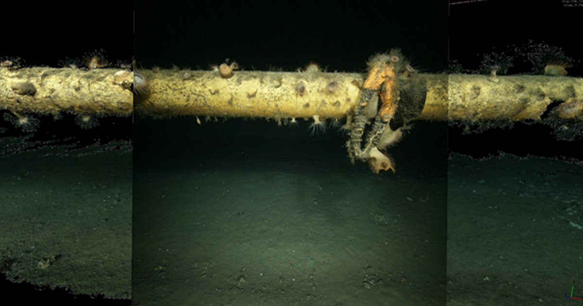
The suitability of photogrammetry for subsea metrology was demonstrated by imaging passes of the seabed without the structure in view. Each pass was completed in less than 30 minutes, proving that this approach could quickly and efficiently capture the required data. Two surveyors on the vessel were supported by a shore-based team, who viewed the survey data as it was streamed via secure infrastructure and the media vault to provide operational support in real time.
This photogrammetry survey using ASVM provided rapid, high-quality results, and the compiled dataset enabled advanced analysis and quantitative measurements of the site. Using this dynamic acquisition method produced immediate feedback on visibility and coverage, making it possible to know as the survey progressed that nothing was impeding data acquisition and that the data being acquired was of the requisite quality.
The in-house team processed the data to produce full color models that allowed the operator not only to assess the position of the assets compared to historic data, but also to identify structural changes, including marine growth on the subsea components and areas of the structure that were experiencing degradation.
The team also was able to compare the conductor locations measured between the jumper inspection dataset and the dataset that only included the conductors and seabed. The result of fitting a best-fit circle to the conductors showed a difference between surveys of only 4.6 mm over 65 m.
The successful execution of this project and the production of a thorough report—complete with images, video, 3D models, and measurements—demonstrates the suitability of this solution for deepwater, subsea inspection.
Applying this technology in subsequent annual surveys will enable complete year-by-year asset comparisons showing the integrity and position of the subsea components, and the comprehensive dataset will enable accurate decision-making for maintenance and intervention.
This successful program demonstrates the technology’s capability, and as metrology becomes more pervasive, there will be opportunities to use ASVM in more environments to capture even greater value for the industry.
This story was originally featured in ON&T’s May issue. Click here to read more.

