Blue-Centric Economy Meets Data Efficiency

Blue-Centric Economy Meets Data Efficiency
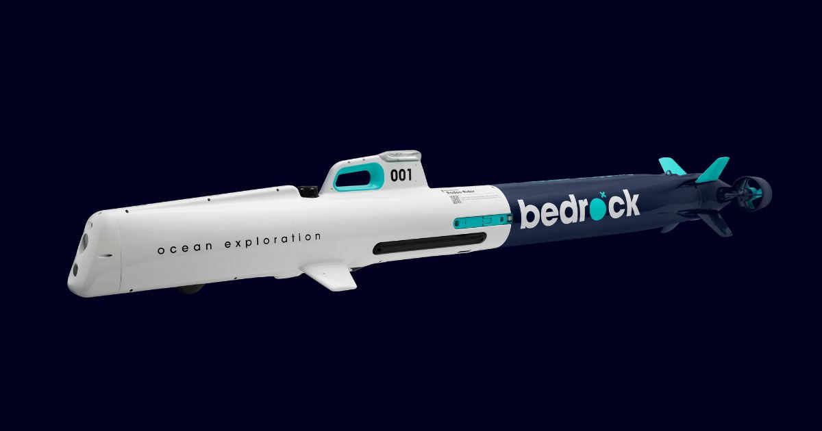
Bedrock Ocean’s proprietary AUV design is instrumental to the company’s vertically integrated data solution. (Image credit: Bedrock Ocean)

Our ocean holds the key to producing clean, renewable energy. It can provide us with the abundant natural resources needed to vastly accelerate global decarbonization efforts. But we currently lack the critical seafloor data needed to unlock this potential within the time frames needed.

Notably, our ability to map the seafloor quickly is a single inhibiting factor to meeting our emission reduction goals. For one, we simply don’t have the capacity to conduct surveys fast enough to get offshore wind farms built at the same time.

Today, it takes four to eight years to build an offshore wind farm from lease signing, in part due to the snail’s pace at which surveying can be done. Pre-construction alone requires between four to seven surveys and every survey campaign can take 12-18 months to complete and get usable data into the hands of engineers. To hit our renewable energy goals, we must now accelerate the rate at which we can complete critical geophysical surveys of the seafloor—and we must do this without leaving a trail of destruction in our wake.

Current seafloor exploration requires expensive, manned, and clunky ships, cumbersome hard drives, and incompatible mapping desktop software, and often doesn’t consider the detrimental effects to our environment and to marine life. The success of surveying also depends on weather, crews, ship infrastructure and availability, which can impose operational, economic, and scalability hurdles.

Post-acquisition, the data collected lives on physical hard drives and flows through desktop computers running on-premises software, not connected to the internet or the cloud. The result is a data lifecycle from raw collection to actionable insight that can take months to move from ship to processor, to geophysicist, to ultimately an engineer and management team who require access to the final geospatial products of a survey. This doesn’t even take into consideration the permitting needed to do traditional geophysical surveying.

It doesn’t need to be this way. The future must be built from a tech-driven blue-centric economy, where much of the critical infrastructure needed to support life will include the ocean in some capacity, coupled with new sophisticated AI-powered technology.

NO-HARM TECHNOLOGY

Unmanned autonomous vessels are key to collecting the much-needed seafloor data. Using fleets of 100% electric powered AUVs immediately mitigates risk to animals or environmental damage in Marine Protected Areas. In addition, this tech can be mobilized more frequently, cost-effectively, and faster than traditional survey vessels. AUVs should be lightweight and portable, mobilizable in days not months. By virtue of this, AUVs can also shave months off permitting time and the associated expenses that traditional topside support cannot escape.

ACCESSIBLE OCEAN DATA

But safe data collection alone isn’t enough. There must be a place where this information can be viewed, analyzed, and shared amongst peers—a single source of truth (SSOT) where data is available and accessible to those that need it.

It’s imperative that we prioritize public access to seafloor data and improve the processing tools we use to interpret that data. Without the necessary data—on our climate, on vulnerable marine ecosystems, and on the geographic potential for renewable energy infrastructure—we cannot harness the full power of our seas to build the sustainable future we need. A free-access, downloadable database of publicly ocean mapping data must be our focus.

NEXT GENERATION NAUTICAL CHARTS

Feeding data into a single point is critical, but visualization is also an integral component to exploration. After all, most of us are visual learners. It’s how we interpret vast quantities of data already. This is where nautical maps come into play. These maps allow us to dive underwater without getting wet, giving us seafloor information through visual representation. It’s these maps that depict coastal topography, bathymetry, landmarks, geographic place names and marine boundaries. Until recently, there were only two types of nautical charts: Raster Nautical Charts (RNC) and Electronic Nautical Charts (ENC). At Bedrock, we believe it is time to take the next step and develop a third type: Web Nautical Charts (WNC).

Initially, the marine industry relied on RNCs, which only showed printed images, but did not allow for data queries. This problem was partially solved with the creation of electronic-based ENCs, which provided electronically rendered vector data that can be shown on registered electronic screens but failed to provide a deeper level of interaction with the underlying data on many different devices.

It’s now time to move onto a whole new category of high-quality maritime web applications and system developments. Ocean data platforms should include WNCs that are interactable on any web browser, on any app, on any machine. This technology should be a fully cloud-native implementation, truly scalable far beyond the current systems. WNCs will be the first ever fully vector-based, API-built charts, engineered for viewing and interacting with all, truly global, ENC data in a developer-friendly way in any platform.

THE ULTIMATE SOLUTION: VERTICALLY INTEGRATED TECH

Eco-consciously built AUVs (even USVs), widely available ocean data, and next generation nautical tools are all necessary for ocean expeditioning, but these tools are only currently distributed amongst different companies and often require a number of complicated, non-compatible software to access and utilize. Piecemealed technology systems requiring complex operational processes pose serious integrational challenges. The solution, and Bedrock Ocean’s core mission, is to establish a vertically integrated technology across the marine industry, where the focus is on data. And most importantly, making that data available easily, and with correct context as to how it can be responsibly used.

New, vertically integrated full-service seafloor data platforms are designed to solve many of the time-consuming, big data problems associated with seafloor surveys, mapping, and ocean exploration in general. Everything—from the way we operationally acquire raw marine survey data to the way it’s stored, distributed, and worked with—needs a new and faster technology solution.

The bottom line is this: without tech that is integrated across the marine industry, we risk never fully understanding how our ocean works. This will be catastrophic, for all that call Earth home. We risk never reaching critical renewable energy and net-zero goals. Ultimately, we risk not mitigating a sustainable future for humanity.

For more information, visit: www.bedrockocean.com.

This feature was originally published in Ocean News & Technology Magazine’s June 2022 edition. Click here to read more.

Image

Corporate Headquarters

Ocean News & Technology
is a publication of TSC Strategic

8502 SW Kansas Ave
Stuart, FL 34997
info@tscpublishing.com