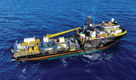
As operators demand faster turnarounds and reduced personnel onboard, the center of gravity for survey work is shifting toward autonomy, remote operations, integrated data workflows and effective data quality assurance processes. That shift is now tangible. In 2025, Oceaneering’s Ocean Intervention II (OI2) vessel underwent upgrades to serve as a cloud‑connected “mothership” for simultaneous operations (SIMOPS), coordinating uncrewed surface vehicles (USVs) and autonomous underwater vehicles (AUVs) while still supporting towed geophysics, hull-mounted data acquisition and geotechnical work from a single platform.
CONCEPT TO PRACTICE
Oceaneering’s remote operations journey began nearly two decades ago, but it quickly progressed in 2015, when the first dedicated Onshore Remote Operations Center (OROC) was launched. Now these seven, global purpose-built facilities provide a safe and secure way to replicate the offshore control environment. This allows pilots, surveyors, and client representatives to monitor, communicate with, and control operations from shore; helping to reduce the personnel on board (POB) required while improving collaboration and increasing access to specialists.
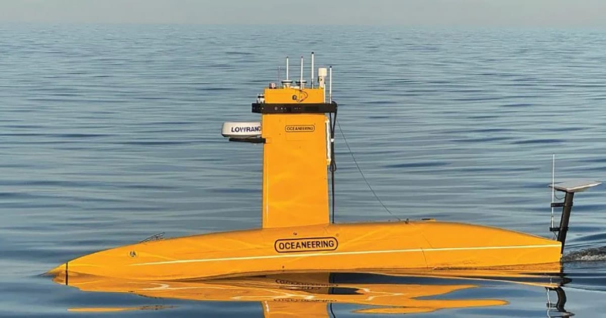
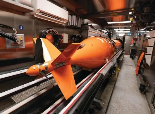
In 2023, Oceaneering introduced a USV service to extend that model into autonomous surveys, and in 2024, the company acquired a DriX USV to operate in tandem with its AUV fleet, including a HUGIN Superior and the Freedom™ AUV system. In 2025, the OI2 modernization connected the dots: a geophysical‑ready vessel coordinating uncrewed assets at sea with onshore command and near real‑time data transfer that shortens the loop between see something and act.
VESSEL UPGRADES
The OI2 refit focused on capability, reliability, and throughput; the three levers that matter most when one platform is orchestrating multiple scopes. Below the waterline, engine room enhancements and maintenance improved day‑to‑day reliability. Topsides, hull‑mounted sensor capacity was expanded. Upgraded navigation and positioning equipment were added and the deck and interior spaces were re-imagined to accommodate survey operations. A dedicated launch‑and‑recovery system (LARS) for USVs and AUVs enables safer, more efficient handling of uncrewed platforms. New computer rack rooms and shipboard IT upgrades tie directly into Oceaneering’s internal network so that prioritized data streams come onshore quickly for quality control, processing, and client collaboration, often while acquisition is still underway.
SIMOPS enables maximized productivity across multiple environments. Depending on the mission, the vessel may conduct towed geophysics or geotechnical work while a USV-AUV team gathers data elsewhere, or the USV can handle shallow-water acquisition as the AUV surveys deeper areas. This adaptability delivers more productive acquisition windows and minimizes remobilizations.
SIMOPS IN THE FIELD
In a typical campaign, a remotely piloted USV serves as the surface companion for an AUV, maintaining high‑bandwidth communications, relaying positioning corrections, and enabling dynamic mission updates. From our OROC consoles, onshore specialists watch incoming data and adapt parameters on the fly, such as tightening line spacing over an anomaly, changing altitude in variable terrain, or re‑tasking the AUV to capture targeted imagery. Meanwhile, OI2 can continue with towed sensors or geotechnical sampling rather than standing by. The operational cadence becomes iterative: detect, decide, and redeploy. Safety and sustainability gains are built in. There are fewer offshore transfers, reduced POB required offshore, and lower fuel consumption relative to running separate, serial vessel campaigns.
PROVEN IN EARLY TRIALS
The DriX USV has accumulated thousands of operational hours since its launch in 2016, combining a slender, highly stable hull with AI‑enabled supervised autonomy to cover ground efficiently and maintain data quality in rough conditions.
In March 2025, Oceaneering remotely controlled a DriX USV over the horizon from its Morgan City, Louisiana OROC, surveying approximately 372 kilometers of seabed with 33 hours of uninterrupted remote piloting. Multibeam and sub‑bottom profiler data were analyzed in near real time by teams in Brazil and Morgan City, enabling swift decisions about features of interest while acquisition continued. These results reinforced expectations that USV‑enabled surveys can keep surveyors onshore, reduce offshore exposure, simplify crewing logistics, and unlock SIMOPS that raise the geoscience “output” of a dedicated survey vessel.
Positioning resilience is central to remote operations. Here, Oceaneering’s C‑NAV® group contributes dual‑path positioning corrections, including a low earth orbit (LEO) satellite‑delivered correction service, to maintain continuity in challenging regions. By diversifying correction sources and leveraging Iridium® satellite’s global network, the architecture mitigates single‑point failures that can interrupt acquisition or erode data quality.
INTEGRATED SIMOPS
For field development planning, the advantages are speed and coherence. Traditionally, teams might run an AUV campaign, demobilize, then return with a towed spread weeks later, stitching datasets together at the end. With SIMOPS, AUV imaging and towed geophysics are collected in overlapping windows, cross‑checked in near real time, and fed into planning models while the vessel is still on station. Hazards can be identified early, allowing for operations to be refined quickly, allowing stakeholders to collaborate on a combined solution. The OI2’s sensor expansion and navigation modernization make these datasets easier to align, while cloud integration helps shore‑based personnel make informed decisions faster.
For asset inspections and route integrity, the pairing of the USV and AUV provides both coverage and fidelity. High‑resolution, repeatable AUV lines can be augmented with quick “look‑again” passes as anomalies are spotted by onshore analysts. The ability to keep OI2 working on another scope while the uncrewed assets do their job further compresses schedules. The net effect is a tighter loop between detection and confirmation and a higher confidence level in the final deliverables.
For environmental baselines and site clearance, the same architecture accelerates both surface and sub‑surface hazard identification and makes laboratory workflows more efficient. Nearshore, the USV’s stability and draft allow swift, low‑impact coverage with minimal fuel. Offshore, our AUV’s sensor packages from HISAS, sub‑bottom data, multibeam, HD camera and laser system provide a holistic approach to all survey scope requirements.
THE MOTHERSHIP STILL MATTERS
Autonomy and remote operations reduce the need for multiple large vessels, but the mothership remains central when operations scale. The OI2’s role is to be a flexible, geophysical‑ready hub that serves as a stable platform for multiple sensor suites; a safe, efficient deck for handling uncrewed assets; and a computer and communications node that stitches sea and shore together.
The 2025 refit was engineered to meet these demands. A dedicated LARS reduces handling risk and cycle time for USVs and AUVs. The navigation overhaul strengthens positional integrity across all scopes. And the Azure‑enabled data backbone keeps specialists, clients, and decision‑makers in the loop, even when they’re miles away.
In an industry that measures risk in days on the water and value in days saved, SIMOPS is more than a buzzword; it’s an operating philosophy. By modernizing OI2 and connecting it to uncrewed platforms and onshore expertise, Oceaneering has turned that philosophy into a practical toolkit. The upgrades remove friction, enabling better, faster data acquisition, and improved decision making.
This feature appeared in ON&T Magazine’s 2025 November Edition, Remote Operations & Force Multiplication, to read more access the magazine here.