The data that continue to feed this global bathymetric map are critical to the study of ocean dynamics, offshore exploration, and a comprehensive policy agenda.
Recently the project—a joint initiative between The Nippon Foundation and the General Bathymetric Chart of the Oceans (GEBCO), itself a joint program of the International Hydrographic Organization (IHO) and the Intergovernmental Oceanographic Commission (IOC)—was formally endorsed as one of the first Decade Actions of the UN Decade of Ocean Science for Sustainable Development.
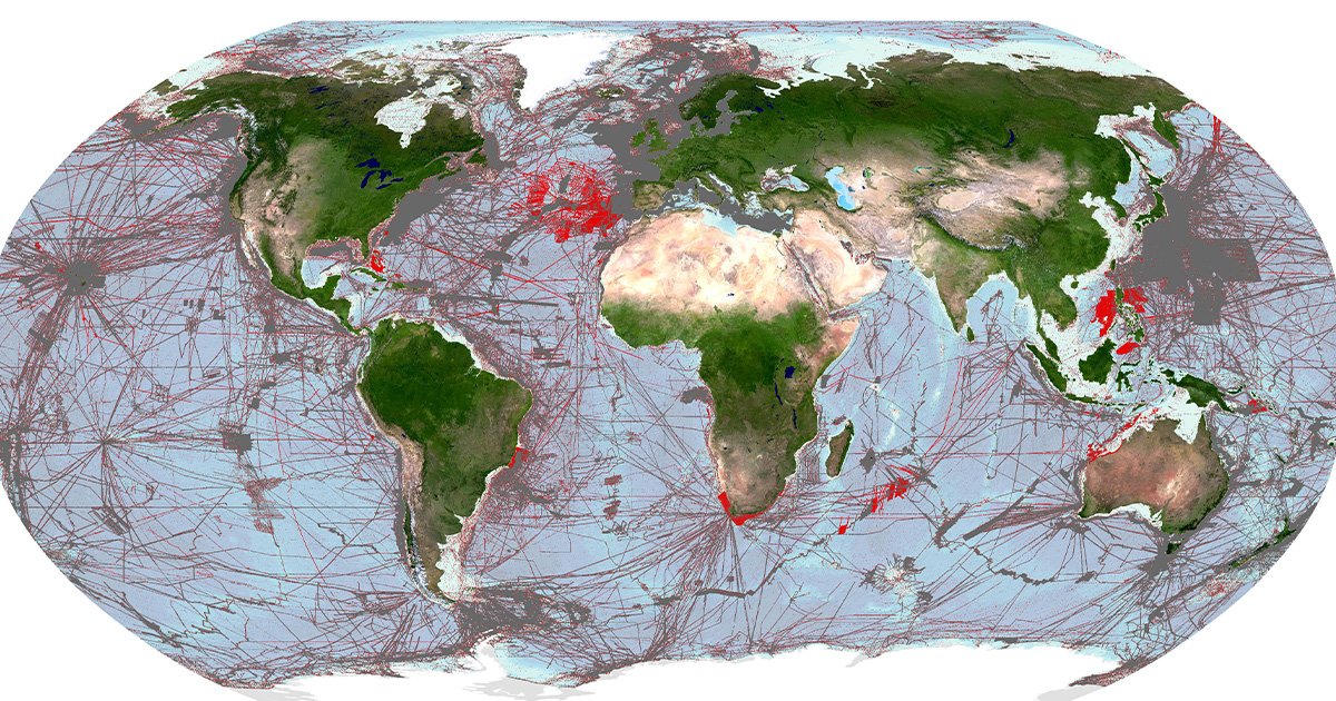
From a starting point of 6% of seafloor coverage in 2017, the project surged through the 20% barrier last June when the grid reached 23.4%. This reflected a year-on-year increase of a massive 10.1 million square kilometers of new bathymetric data, an area roughly equivalent to the size of Europe. That 23.4% milestone, however—as significant as it is—also underlines how far there is still to go to achieve the 2030 target of 100% coverage.
CROSS-SECTORAL APPROACH
With lots of hard work completed and essential infrastructure now in place—from overarching strategy to the establishment of a network of six centers in strategic locations globally—the platform for more progress is sound. To meet its ambitious objective, the Seabed 2030 project has highlighted strategic partnerships as being critical to success, encouraging ocean data collectors across all sectors to collaborate in as many ways as possible.
By means of example, academic partnerships have included activities with the Brazilian Program of Marine Geology and Geophysics (PGGM) a network of Brazilian academic and scientific institutions working to develop the understanding of the Brazilian continental margin and the adjacent ocean basin—the South Atlantic.
NGOs and not-for-profit organizations also have a powerful role to play, as evidenced by REV Ocean committing to contribute bathymetric data and to the sharing of innovative ways of mapping the ocean and managing the resulting data.
Engagement with governmental bodies is also critical. Most recently, efforts here have been typified by a memorandum of understanding with the Ministry of Information, Communications and Transport (MICT) for the Republic of Kiribati, and the National Mapping and Resource Information Authority (NAMRIA) of the Philippines.
Industry, too, has been proven instrumental to current progress. Not only do commercial enterprises collect a lot of bathymetric data for a variety of purposes, but they also push the boundaries of technological advancement, so that seafloor data can be collected faster, to higher resolution, and at reduced cost. Recent Seabed 2030 collaborations with industry have included a focus on innovative autonomous underwater vehicles (AUVs) (with ecoSUB Robotics); uncrewed surface vehicles (USVs) (with Saildrone); cloud-based, crowdsourced bathymetry (with Orange Force Marine); and data visualization exploration (with Terradepth).
GREEN TRANSITION
The underlying principle of this collaborative partnership approach is a reassuringly simple one: the more seabed data everyone contributes, the more benefit everyone derives—from academics to NGOs, from offshore planners to policy makers.
One perspective overarching each individual sectoral focus is the burgeoning, holistic prospect of the Blue Economy. The Blue Economy involves adopting an environmentally sustainable approach to the promotion and development of marine regions and resources. Continued investment in the Blue Economy as countries look to transition to a greener future—one that is significantly less carbon intensive and more resource efficient.
That means harvesting previously untapped renewable energy sources—wind, wave, tidal, and solar—from coastal and offshore environments, many previously unchartered.
In this way, the Blue Economy and the so-called “Green Energy Transition” have become deeply interconnected, as knowing the depth and geophysical properties of the seafloor is essential to offshore planning and, subsequently, the safe, efficient, and responsible build out of offshore infrastructure.
SURVEYING AREAS OF INTEREST
Further scaling up of seabed data collection will only happen with a strategic approach. This is where the power of partnership goes beyond the hard bathymetric data itself, to converting the shared knowledge and understanding prevalent across each contributing sector into a unified, evidence-based strategy. The first harnessing of such collective knowledge for the Seabed 2030 project came in 2021, when an initial online survey of views on seabed mapping attracted nearly 800 responses from professionals representing 90 countries.
The findings of that initial global survey highlighted a number of important themes—for example, that the main benefit of mapping the ocean floor was considered to be ‘to advance scientific understanding of seabed characteristics’ (40% of respondents who were asked to express a ranked preference); that bathymetric data (82% of respondents) was the most desired geospatial information; that water depths less than 200 m (34%) and greater than 5,750 m (31%) were of greatest interest; and that an overwhelming majority of professionals (58%) wanted access to any data sets via an online marine data portal.
But that was just the beginning. Further analysis of the survey data, and engagement with a wide range of stakeholders, has led to more detailed understanding of needs, and the project is now looking to consolidate on that thinking with an additional survey.
The purpose of this new survey is to inform the development of a comprehensive benefits analysis of seabed areas yet to be surveyed. This in turn will lead to prioritization modelling to inform business case development for individual survey missions, so that Seabed 2030 and its partners can deliver on its mission to map our ocean seabed by the end of the decade.
The survey is intended to be addressed by bodies and agencies who discharge national, regional, and international responsibilities for seabed mapping and people engaged in the acquisition, production, and use of seabed mapping data, drawn from the global community of hydrographic and oceanographic authorities, and other government agencies.
To access the latest survey, please visit www.surveymonkey.com/r/S2030Survey.
For more information about Seabed 2030, visit: www.seabed2030.org.
This story was originally published in ON&T Magazine’s May 2023 Issue. Click here to read more.