Understanding the precise location of an autonomous surface vessel (ASV) is critical to its safe and successful navigation. Traditionally this has relied on Global Navigation Satellite System (GNSS) to provide positioning to a few meters. However, issues with multipath, jamming, spoofing, and solar activity can hinder GNSS accuracy, calling into question its reliability for truly autonomous operations.
With traditional marine radar failing to provide the cm-level of accuracy required for autonomy, many ASV developers are now looking at camera and LiDAR technology thanks to their successful application in land-based autonomy projects. However, cameras perform poorly in the unfavorable weather, common at sea, and LiDAR lacks the sufficient range required for full marine autonomy.
USV/AUV developers need a sensor that can accurately provide GNSSdenied positional information, whilst being resilient to changes in external conditions.
THE VALUE OF RADAR
Navtech Radar recently developed a radar-based approach to autonomous navigation that utilizes W-band radar (76-77GHz). The solution is known as Terran360 and is the world’s first single-sensor radar localization solution. Unlike typical marine radars that use X-band (8-12GHz) frequency, Navtech’s millimeter-wavelength radar provides greater resolution, resulting in a rich data source to build up a clear picture of the local environment. Terran360 combines Navtech’s highresolution sensor with Oxboticas best-in-class radar localization algorithm.
Terran360 builds a high-resolution map of the environment using radar data to extract key natural landmarks. This allows a vessel to position itself to cm-level accuracy, using a single Navtech radar, making Terran360 the ideal localization solution in GNSS-denied environments such as ports or inland waterways.
TERRAN360 IN ACTION
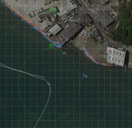
Navtech Radar recently conducted field testing of Terran360 in Devon, UK. Localization accuracy for the trial was directly compared to onboard GNSS with correction services. One traversal of the designated route was completed to build up a map of the environment using radar data. Subsequent runs of the same route were then completed in order to localize against it. Terran360 uses around 10 MB/km of space for map building, meaning that only less than 3.5 GB of space would be needed to map the whole of the River Thames.
Navtech concluded from these results that Terran360 was able to accurately determine vessel position to less than 10 cm throughout the journey when compared to the onboard GNSS. Navtech also noted that the system was able to localize in instances where landmarks were often over 250 m away.
SCALING AUTONOMY
As marine operators look to scale their autonomy projects, Navtech Radar is currently working with early adopters to carry out full trials of Terran360 and demonstrate how the easily integrable technology outputs its position over a standard NMEA UDP string. By fusing Terran360’s radar map with GNSS, the system can output positional information in a UTM frame of reference.
To find out more, visit: http://www.navtechradar.com/
This story originally appeared in ON&T’s September 2022 issue. Click here to read more.