The sonar imagery did, however, unveil two 19th-century shipwrecks and a catalog of previously unknown geological features of significance, including fractures, subsea canyons, and seafloor volcanoes. Sonar systems, in every sense and application, have the capacity to piece together history—whether natural or manmade in origin.
There was another, more recent episode of sonar-related furor in 2024, following a strong suggestion that sonar imagery captured about halfway between Australia and Hawaii might belong to Amelia Earhart’s long-lost Lockheed Electra. However, after a period of stringent geospatial analysis, the seabed anomaly was confirmed as a distinct, “planeshaped” rock formation. Once again, high-resolution data, zero resolution to the mystery.
While these two cases remain open, with over 70% of the planet’s surface covered by water and increasingly concerted efforts to map the ocean floor and significant lakebeds to a meaningful resolution, a steep incline in the volume of sonar-assisted discoveries is all but inevitable, whether by design or by chance.
CHARTING AVIATION HISTORY
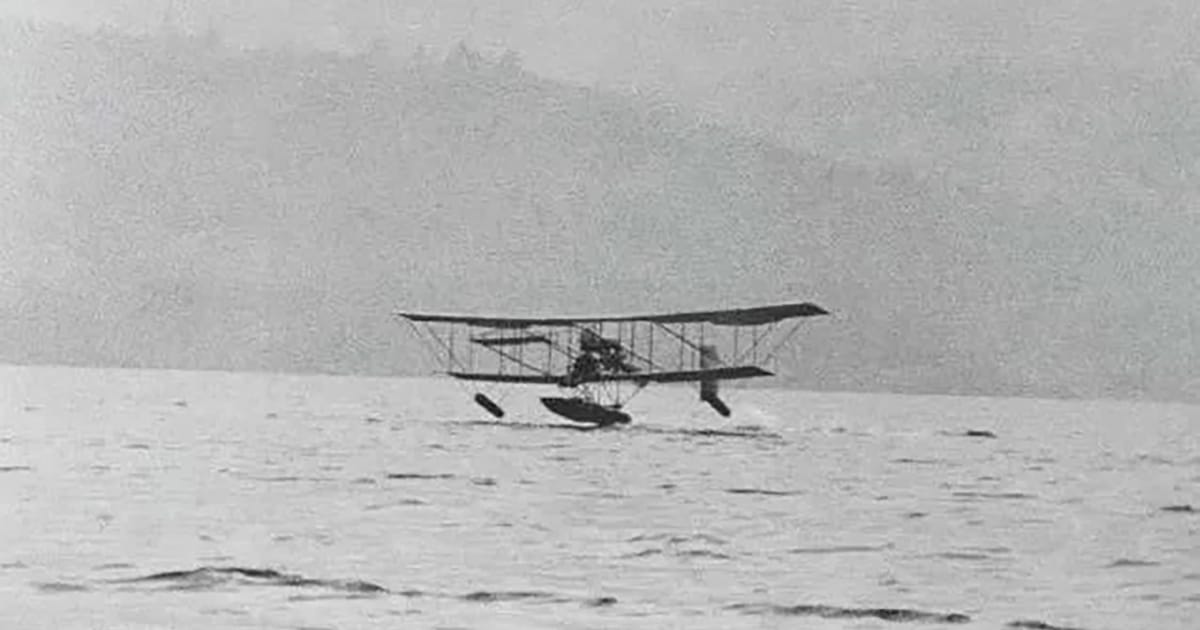
In the winter of 1911, aviation history was made on the still waters of Windermere, a large lake in Cumbria’s Lake District National Park, northwest England. Above the surface of this picturesque and much celebrated body of water, Waterbird rose gracefully, completing the United Kingdom’s first successful hydroplane take-off, flight, and landing. Waterbird, also referred to as the Avro Curtiss- type, was developed by the Windermere-based Lakes Flying Company and propelled the nation’s future in seaplane development, transforming the local surrounding area—one traditionally associated with tourism, arts, and agriculture—into an unlikely hub of aviation innovation. For years afterwards, engineers and pilots tested and refined new aircraft along its shores, turning the lake into a testing ground for both civil and military seaplanes.

More than a century later, that pioneering spirit returned to Lake Windermere, this time beneath the surface, thanks to the interest and dedication of local historian Ian Gee in preserving the region’s aviation heritage. Through years of ongoing research, he has successfully traced the local people and technologies that once defined this golden era of early flight. But there was one part of the Waterbird story that continued to elude Gee: the role of a barge thought to have been instrumental in transporting the novel hydroplane across the lake.
Historic photographs hinted that this barge was integral to the aircraft’s operations; however, no record of its fate survived. The prevailing theory suggested it had sunk somewhere near the original launch site. Traditional search methods offered little hope as visibility in the lake is generally poor. To solve this mystery, Gee sought out help from Blueprint Subsea—it was time, once again, for a sonar solution.
PRECISION IN SHALLOWS
Blueprint Subsea’s team selected the StarFish 990F, a compact, high-frequency side-scan sonar specifically designed and calibrated for shallow-water operations. Operating at 1 MHz, the 990F delivers ultra-detailed acoustic imagery, ideal for detecting objects and distinguishing man-made shapes from natural features. Using StarFish Scanline software, the team could view and analyze sonar returns in real time. At first, the scan revealed the usual underwater landscape, then, a more defined shape began to emerge: a long, rectangular outline with evenly spaced ribs, unmistakably the form of a vessel.
The sonar imagery was strikingly clear. Using Scanline’s built-in measurement tools, the Blueprint Subsea team confirmed the object’s proportions matched historical estimates of the Waterbird barge’s size. The wreck appeared largely intact, its linear features suggesting a flat-bottomed design typical of work barges used on Windermere during the early 1900s.
Once the coordinates were recorded, a team of local divers prepared to investigate further. Guided precisely by the sonar data, they descended into the lake the following day.
Despite near-zero visibility, the divers located the structure exactly where the sonar indicated. Illuminated by their lights, the wreck’s wooden frame and fittings came into view, including a mechanical winch system thought to have been used to tow the hydroplane out onto the lake for its flight trials.
The evidence was compelling. After more than a century beneath the surface, the Waterbird barge had finally been found. The project illustrated how sonar technology can extend beyond commercial and scientific domains to support heritage and archaeological work.
Designed and manufactured in the UK, the StarFish series provides marine professionals with portable, high-resolution sonar imaging. Systems are routinely used for hydrographic surveys, underwater inspections, environmental studies, and search-and-recovery operations—and, as this case shows, for uncovering pieces of history.
This feature appeared in ON&T Magazine’s 2026 January Special Edition, The Future of Ocean Technology Vol. 6, to read more access the magazine here.