Technology as the Enabler
There is an old saying in modeling, and it applies here: “Garbage in, Garbage Out!” The problem is not so much one of modeling as it is of the data entered into the models. Huge gaps in resolution of the needed in-situ ocean data prevent models from performing consistently. Sometimes they work and sometimes they completely break down. SeaWARRDD Technologies offers an integrated solution with an initial focus on an area in Florida but with the potential to transform hurricane forecast accuracy around the globe in critical regions.
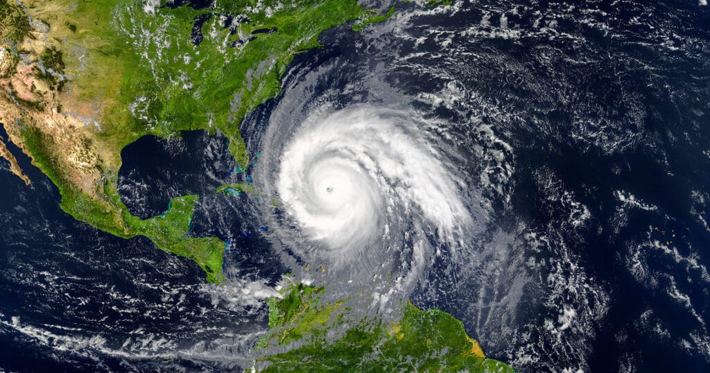
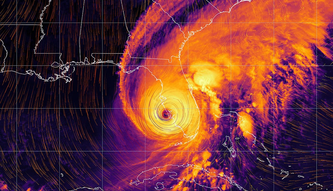
Current storms are outsmarting modelers, with significant deviations in track and intensity repeatedly catching coastal and inland communities by surprise. The lack of high-resolution in-situ Metocean observing systems for the water column and boundary layer, particularly over continental shelf coastal areas, undermines the accuracy and reliability of hurricane modeling.
Rapid Intensification Risks
As hurricanes approach land, threatening communities and infrastructure, they transit from deep ocean to shallow continental shelf waters. Rapid intensification and track changes are a severe risk as this takes place. Hurricane Otis (2023) provides a striking example. Forecasts predicted only a tropical storm (of around 50 mph) that would turn west and weaken, but instead, Otis turned east and rapidly intensified in just 12 hours into a Category (Cat) 5 hurricane (of around 165 mph) before striking Mexico’s coast and devastating Acapulco. The underlying conditions that made this extreme meteorological event possible were entirely missed by forecast models forced to rely on remote satellite Sea Surface Temperature (SST) and “synthetic” data techniques to cover gaps in real in-situ data.
Other recent examples include Ian (2022) which struck Florida after unexpected rapid intensification and track change killing 162 people and causing $112 billion in damage. This rapid intensification occurred as Ian moved over the West Florida Shelf (WFS), a broad region in the eastern Gulf of Mexico. Crucially, no, to very little real-time water column density data (such as conductivity/ salinity, temperature, and pressure/depth) were available along Ian’s track to inform forecasting models.
In fact, Florida has recently seen multiple hurricanes substantially deviate from initial forecasts, a few examples include Michael in 2018 (Cat 1 to Cat 5 causing over $60 billion damage); Dorian in 2019 (which triggered a false evacuation of millions of residents before rapidly intensifying and stalling over the Bahamas before turning northeast); Idalia in 2023 (Cat 2 to Cat 4); and Helene in 2024 (Cat 3 to Cat 5, making landfall as a Cat 4 after growing into a truly massive diameter, with 17 foot storm surge along the coast and then pushing deep inland causing catastrophic flooding to North Carolina.)

Alarming Data Gaps
However, there is a notable lack of high-resolution, high-frequency oceanographic data, particularly from systems that capture temperature and conductivity across different ocean depths. This data gap has been widely recognized in academic research as a critical limitation. For instance, Glenn et. al. highlights how the absence of real-time, highfrequency data restricts the ability to monitor hurricane progression through sea-surface cooling patterns. Similarly, when developing a Convolutional Neural Network (CNN) model to predict hurricanes in the Atlantic, Astha et. al. had to oversample ground-truth data due to the limited availability of (in-situ) observations. Moreover, as climate change alters hurricane dynamics, high-resolution, contemporary data is essential to understanding these evolving processes for accurate forecasting and modeling.
Accurate, high-density data is essential for legacy models and for developing precise machine learning AI models for hurricane prediction, as these systems are driven by complex, nonlinear interactions between atmospheric and oceanic conditions. Machine learning models rely heavily on the quality and quantity of input data, and high-resolution data enable more detailed feature extraction and pattern recognition. Key water-column variables such as conductivity, temperature, and depth (CTD), related to surface metocean variables, provide insights into the ocean’s vertical structure, which is critical for assessing the thermodynamic state of the ocean. For instance, temperature gradients, particularly across the thermocline, influence the heat exchange at the surface between the ocean and atmosphere, directly affecting hurricane intensity.
Where data is sparse, uncertainty in forecasts is highest. Relying on “synthetic ocean data” in-situ multi- simply is not effective in capturing the critical variables. Comprehensive parameter baseline data and event-response data collection capabilities are essential.
Catastrophic Hurricane Damage
The Office for Coastal Management has highlighted the staggering financial impact of hurricanes on the United States, stating that; “as of August 2023, tropical cyclones (or hurricanes) have caused the most damage in the US, totaling over $1.3 trillion, with an average cost of $22.8 billion per event.” Additionally, the US National Oceanic and Atmospheric Administration (NOAA), emphasizes the critical need for enhanced hurricane forecasting and tracking capabilities. They note that; “Improving hurricane track and intensity forecast predictions is essential for protecting the public and reducing property damage. Early warning improvements in intensity and track forecasts for hurricanes greatly benefit public preparedness actions and emergency management decision-making.”
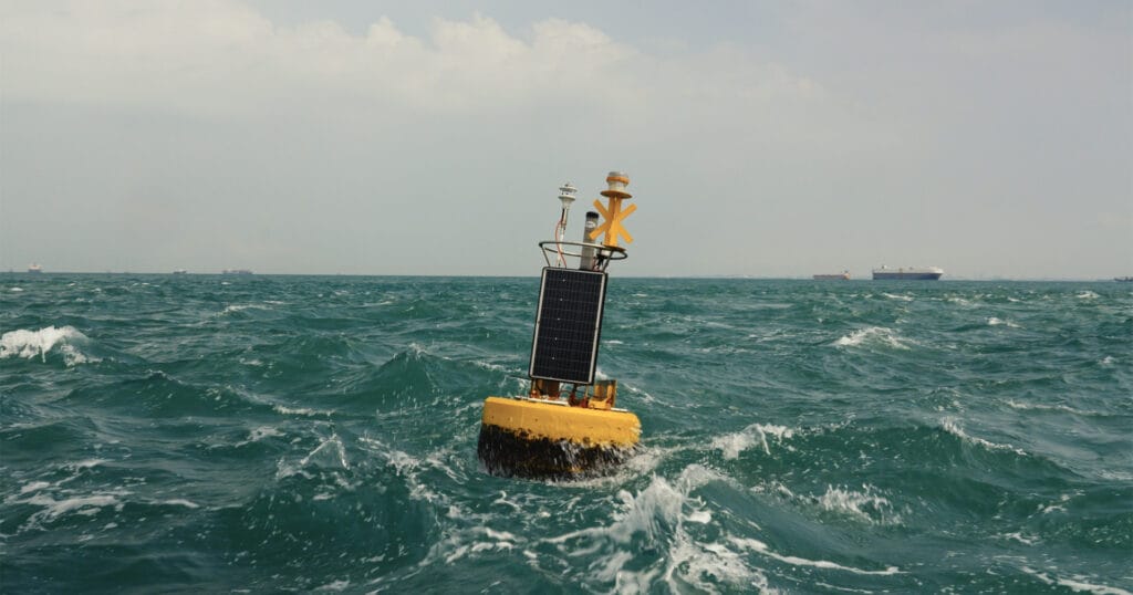
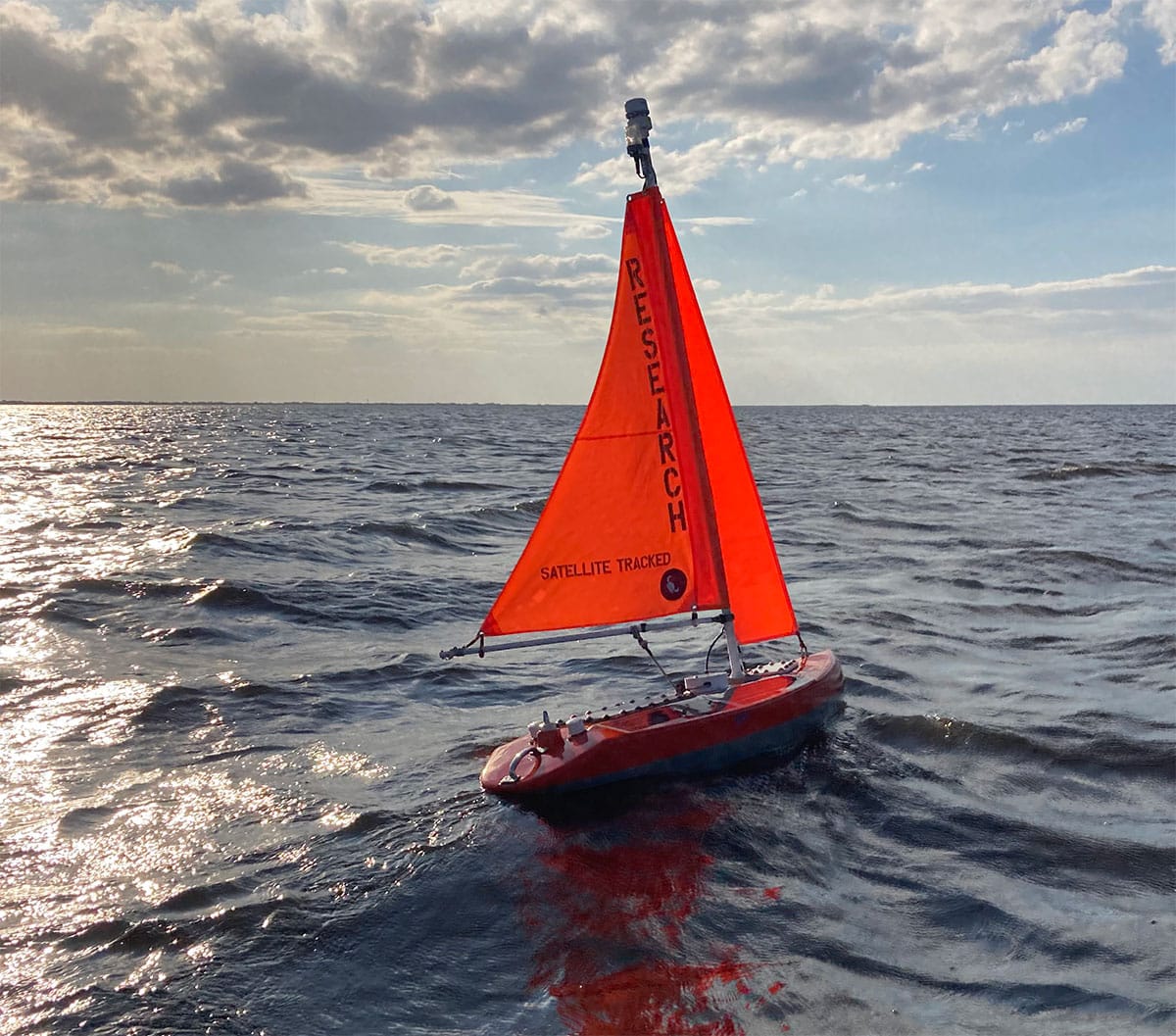
Hurricane SHIELD represents an ecosystem of autonomous ocean monitoring platforms. (Credit: SeaWARRDD)
Enhancing Forecast Data
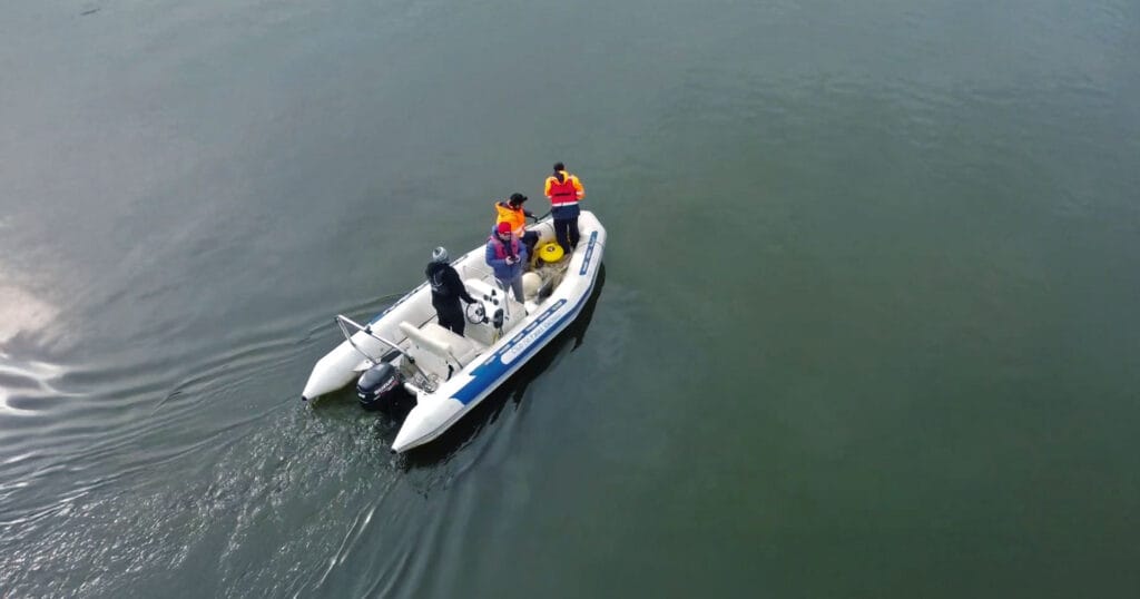
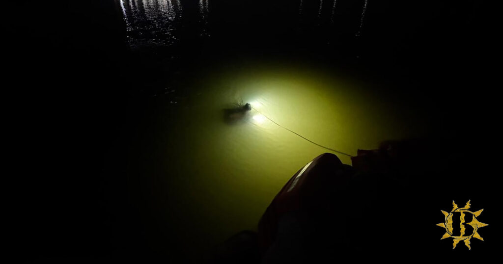
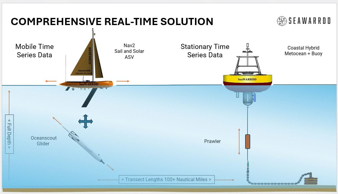
The “Coastal Warning and Rapid Response Data Density System” (SeaWARRDD) is specifically designed to enhance hurricane forecast data collection by capturing comprehensive in-situ Metocean+ data. Sea- WARRDD provides detailed insights into the ocean-atmosphere boundary layer and the water column below. SeaWARRDD’s coordinated, multi-platform approach integrates essential stationary time-series data with mobile time-series data, offering both regional coverage and rapid-response adaptability to emerging events. Capabilities include real-time mission control, data transmission, display, archiving, advanced analytics, and the development of tailored data products for specific end users.
For stationary time-series data, both at the surface boundary layer and in the water column below, state-of-theart Metocean+ RDSEA moored buoys are deployed, utilizing underwater “PRAWLER” CTD technology (wire crawlers). Meanwhile, for mobile measurements, Nav2 ASV Metocean+ surface & water-column current profile data is paired with mobile underwater Oceanscout Gliders, (Hefring Engineering, MA). SOPHIA AI by SeaWARRDD partner Atmos-Marine provides rapid analytics of emerging data which can then be used to adapt data collection strategy which in turn further enhances analytic outputs.
The Florida Hurricane Shield
SeaWARRDD is introducing the State Hurricane Intelligence & Early-Warning Data System (Hurricane SHIELD) for Risk Reduction & Insurance Stabilization to directly improve hurricane forecast accuracy, public safety and emergency response, while reducing false evacuations, economic damage, and stabilizing property insurance viability in Florida.
Why This Matters to Florida
-
Florida has the highest hurricane exposure in the United States with over $3 trillion insured property value;
-
Hurricane intensity and track forecasts remain highly uncertain;
-
Millions of people face risk to life and property, unnecessary evacuations, emergency preparedness mistakes, and increased recovery costs;
-
Billions of dollars in avoidable costs to people, homes, businesses, critical infrastructure, and high value assets, per hurricane;
-
Higher premiums and actuarial risk threatening state-wide insurance viability;
-
Risk of financial shock to the insurance industry and Citizens Property Insurance exposing policy holders and taxpayers to billions of liabilities;
-
For insurers and reinsurers, improving risk intelligence in Florida is one of the highest leverage investments in catastrophe risk reduction available anywhere in the US.
Autonomous Ocean Observation
Hurricane SHIELD will deploy a comprehensive network of advanced autonomous ocean observing platforms positioned offshore of Florida in a protective monitoring array:
These systems will collect real-time ocean/ atmosphere data for hurricane prediction; provide improved hurricane forecast and impact models to the public, emergency decision makers, and the property insurance industry; improve long-term hurricane risk analytics critical to stabilizing property insurance; and help realize projected financial benefits to Florida totaling anything from $6 billion to a possible $18 billion a year.
The Future
SeaWARRDD sets the stage for comprehensive, coordinated, multi-platform ocean data collection, transforming the science of hurricane forecasting and impact prediction. Current storms are outsmarting modelers, with significant deviations in track and intensity repeatedly catching coastal and inland communities by surprise. The lack of high-resolution in-situ Metocean observing systems for the water column and boundary layer, particularly over continental shelf coastal areas, undermines the accuracy and reliability of hurricane modeling.
SeaWARRDD plans to implement its observing system in targeted high-value areas, beginning with the West Florida Shelf in the US, partnering with existing monitoring programs. Customized SeaWARRDD data sets, along with their derived analyses, models, and improved hurricane forecasts, will be provided to end-users across various sectors, including industry, science, and local communities.
Our team—with decades of experience across the federal, state, academic, and private sectors—has proven success of designing, developing, installing, and maintaining ocean monitoring and data collection systems, globally, including bays and estuaries.