Called GOFLOW (Geostationary Ocean Flow), the approach uses AI to analyze thermal images from weather satellites already in orbit. Because it relies on existing satellites, no new hardware is needed, marking what researchers describe as a major advancement in ocean observation.
The study was co-led by Luc Lenain of Scripps Institution of Oceanography at the University of California, San Diego, and Kaushik Srinivasan of the University of California, Los Angeles. Co-author Roy Barkan of Tel Aviv University and Pizzo is also an alumnus of Scripps. The project was supported by grants from the Office of Naval Research, NASA, and the European Research Council.
Ocean Currents and Vertical Mixing
Ocean currents play a huge role in shaping Earth’s weather and climate, transporting heat around the planet, moving carbon between the atmosphere and ocean interior, and carrying nutrients that support marine life.
“In areas where the ocean pushes together and pulls apart, information from the atmosphere and ocean interior are exchanged in ways we do not fully understand,” said Pizzo. “This is one of the most exciting areas of physical oceanography today.”
Understanding currents is also important for search-and-rescue efforts and tracking the movement of oil spills. Yet measuring currents across large areas of the ocean has remained extremely difficult. Some satellites only revisit the same location about every 10 days, too infrequently to capture currents that can appear and disappear within hours. Ships and coastal radar can track faster changes, but only in limited areas.
This has left a persistent gap in observations at the scales where most of the ocean’s vertical mixing occurs—when shallower waters are mixed deeper or vice versa. The phenomena that drive vertical mixing can be less than 10 kilometers (six miles) wide and transform in hours. Understanding vertical mixing is important because it powers key processes such as bringing nutrients up to the surface and pumping carbon dioxide to the deep ocean, where it is stored long-term.
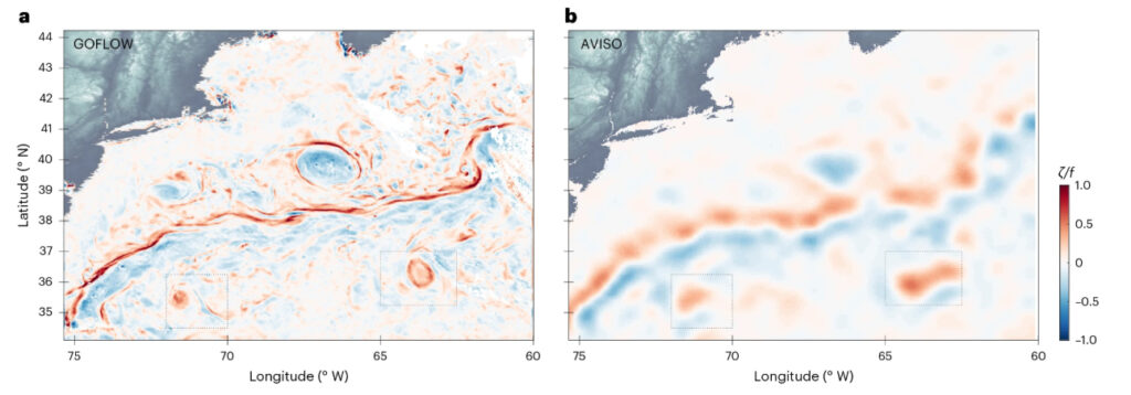
A side-by-side comparison of ocean surface velocity and vorticity fields in the same region, showing GOFLOW (a) alongside AVISO (b). While the AVISO map is built from a 10-day average, the GOFLOW map is built from hourly data, revealing greater detail. (Image credit: Luc Lenain, Scripps Institution of Oceanography)
Deep Learning
The GOFLOW team trained an AI model to recognize how surface temperature patterns shift as water moves below. The neural network model learned from advanced computer simulations of ocean circulation, then applied that knowledge to real satellite imagery from the North Atlantic collected by the GOES-East weather satellite. The researchers tested the method against shipboard observations in the Gulf Stream and found that GOFLOW matched existing measurement techniques while revealing much finer detail, capturing smaller, more energetic features linked to vertical mixing.
For scientists such as Pizzo, these advances create new opportunities to study ocean dynamics using actual observations, rather than relying primarily on computer models.
“We are using this real-world inference to better understand how the ocean transports important quantities like heat from one place to another, and how vertical motions that are important for exchanges between the atmosphere and the ocean are supported,” said Pizzo.
Because GOFLOW works with satellites already in service, the method could eventually be integrated into weather forecasts and climate models, helping improve predictions of ocean-atmosphere interactions, marine debris transport, and ecosystem change. The researchers are now working to expand the method globally and improve performance when cloud cover blocks satellite views.
This story was written by Mackensie duPont Crowley, digital communications coordinator in URI’s Graduate School of Oceanography.