The mission continues a multi-year collaboration between NOAA and Saildrone that began in 2021. NOAA scientists will define the operational objectives and provide mission tasking as tropical storms develop; Saildrone will operate and navigate the USVs to deliver in situ oceanographic and meteorological data in real time.
The Saildrone Explorers will be strategically positioned in the western tropical/subtropical Atlantic Ocean, Caribbean Sea, and Gulf of America from July to November. As tropical cyclones develop, Saildrone mission operators will coordinate with NOAA to position the USVs in and around storms.
NOAA scientists at the Atlantic Oceanographic & Meteorological Laboratory (AOML) and the Pacific Marine Environmental Laboratory (PMEL) will use Saildrone data to study how exchanges of heat, moisture, and momentum between the ocean and the atmosphere influence storm intensity. Rapid intensification, defined as an increase in a hurricane’s maximum sustained winds of at least 30 knots (35 mph) in 24 hours, remains one of the most difficult hurricane behaviors to predict.
“This multi-year mission between NOAA and Saildrone is helping to improve our understanding of how hurricanes intensify, including when they strengthen rapidly before landfall,” said Greg Foltz, an oceanographer at NOAA and one of the principal investigators on the mission. “Each storm we observe gives us more data to evaluate and improve prediction models, which is critical for increasing forecast confidence, extending warning lead times, and strengthening the nation’s preparedness for high-impact weather events.”
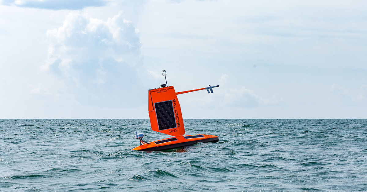
Each Saildrone Explorer will be equipped with a suite of meteorological and oceanographic (metocean) sensors to measure wind speed and direction, air, surface, and sub-surface temperature, relative humidity, barometric pressure, salinity, and wave height and period. Additionally, two USVs will carry NOAA ASVCO2 sensors to measure carbon dioxide exchange between the ocean and the atmosphere. These observations will support NOAA’s hurricane research and modeling efforts.
“The NOAA hurricane mission is one of Saildrone’s longest-running and most successful partnerships, and also one of the most technically demanding,” said Matt Womble, Vice President of government relations at Saildrone. “This mission reinforces the value of mature, long-duration uncrewed systems for operating in environments where persistent data collection is otherwise impossible by traditional means. Better hurricane data supports better forecasts, and better forecasts strengthen national resilience—protecting lives, infrastructure, commerce, and critical operations. Saildrone is tremendously proud to continue this work with NOAA.”
Hurricanes pose a major threat to national and economic security, with impacts that can include loss of life, severe damage to homes and businesses, disruption to ports and supply chains, impacts to critical infrastructure, and interruptions to military and emergency-response operations. According to NOAA’s National Centers for Environmental Information (NCEI), between 1980 and 2004, tropical cyclones accounted for 52.9% of all billion-dollar disasters in the United States—more than wildfires, drought, flooding, freeze, severe storms, and winter storms combined. The estimated total damages (CPI-adjusted) from tropical cyclones over that time period exceed $1.5T.
Recent storms, including Hurricane Idalia in 2023, Hurricane Ian in 2022, and Hurricane Harvey in 2017, have rapidly intensified just before landfall, underscoring the need for better observations in the ocean regions where storms gain strength. NOAA aims to improve weather forecasting models, ensuring that state and local officials, and by extension the general public, receive longer lead times to prepare and evacuate accordingly.
Saildrone has supported NOAA hurricane research across multiple seasons, deploying five USVs in 2021, seven in 2022, and 12 in both 2023 and 2024. Saildrone Explorers are multi-mission USVs, and several have been deployed on multiple hurricane missions; to date, 21 different USVs have been used in these missions. Since 2021, Saildrone has intercepted 21 named hurricanes and tropical storms on 46 occasions. In total, Explorer USVs have spent more than 2,600 days on mission supporting hurricane research. During each mission, Saildrone’s fleet has been co-located with NOAA’s aerial and sub-surface assets to form a comprehensive picture of the air and water column.
The Saildrone Explorer is a 7-meter (23-foot) USV designed to deliver continuous metocean observations across remote and extreme environments. The USVs used for the hurricane monitoring mission are equipped with a shorter, ruggedized “hurricane” wing, designed for the extreme wind and sea state conditions inside a tropical cyclone.
In addition to the 2026 hurricane mission, Saildrone will operate more than 75 USVs globally this year, supporting national and homeland security, ocean mapping, and research.