In simple terms, bombogenesis is a storm that undergoes rapid strengthening. The vast majority of such storms occur over the ocean. The storm can be tropical or non-tropical in nature.
Other common phrases for bombogenesis include weather bomb, or simply bomb.
The term bombogenesis comes from the merging of two words: bomb and cyclogenesis. All storms are cyclones, and genesis means the creation or beginning. In this case, bomb refers to explosive development. Altogether the term means explosive storm strengthening.
 A cyclone (non-tropical storm or hurricane) is essentially a giant rising column of air that spins counterclockwise over the Northern Hemisphere.
When air rises, it produces a vacuum effect that results in lower atmospheric pressure.
When a storm strengthens, the column of air rises at a faster and faster rate and the pressure within the storm lowers.
Meteorologists use a barometer to measure the atmospheric pressure. Atmospheric pressure is often called barometric pressure.
Average storms in the winter have a low barometric pressure reading of 29.53 inches of mercury.
Some of the most intense storms may have the barometric pressure below 29.00 inches.
However, it is not the lowest pressure that defines bombogenisis but rather how quickly the pressure within the storm plummets.
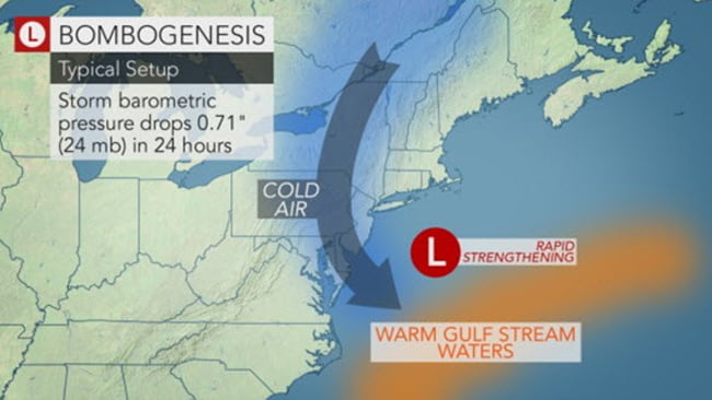
When the barometric pressure falls at least 0.71 of an inch (24 millibars) in 24 hours, a storm has undergone bombogenesis.
For example, a weak storm that began with a barometric pressure of 29.98 inches and ended up with a barometric pressure of 29.27 inches in 24 hours underwent bombogenesis.
The Superstorm of 1993 (Storm of the Century) from March 12-13 is a prime example of a storm that underwent bombogenesis. The storm strengthened from 29.41 inches (996 mb) to 28.45 inches (963 mb), or nearly 1.00 inch (33 mb), in 24 hours. Much of this strengthening occurred over land.
 This animation shows the evolution of the March 1993 superstorm. (NOAA/satellite)
Other examples of storms that underwent bombogenesis are Hurricane Charley in 2004 and Hurricane Wilma in 2005. The Blizzard of 2015 (Jan. 26-27), the Bering Sea storm of December 2015 and the northeastern United States storm of late-October 2017 experienced bombogenesis.
Storms that undergo bombogenesis are among the most violent weather systems that affect a broad area. This is because the rapidly ascending air near the center of the storm must be replaced by air surrounding the storm. As these winds move toward the center of the storm at high speed, property damage can occur, trees may fall and the power may go out.
The western North Atlantic is one favored area for storms to undergo bombogenesis. This is a region where cold air from North America collides with warm air over the Atlantic Ocean. Warm waters of the Gulf Stream may also provide a boost in a festering storm.
As a result, some, but not all nor’easters may undergo bombogenesis.
The intense winds often create massive seas and may cause significant beach erosion.
In terms of precipitation, very heavy rain and/or snow may fall in the path of the storm undergoing bombogenesis.
Precipitation rate is produced from the rising column of air. When air rises, it cools and moisture condenses to form clouds and rain or snow. The faster the air rises and cools, the heavier the precipitation.
By Alex Sosnowski, Senior Meteorologist for AccuWeather.com


