Why It Matters
El Niño events have significant impacts on marine ecosystems and coastal communities. MBARI research and technology are providing data needed to monitor ocean health and advise resource managers assessing coastal geohazards.
For more than 30 years, MBARI technology has recorded real-time data about Monterey Bay, from oceanographic conditions at the surface to biological surveys in the depths of Monterey Canyon. These data are integral to understanding our changing ocean and underpin the institute’s efforts to monitor the impacts of the incoming El Niño, which has been predicted to be among the strongest since the beginning of modern oceanography.
Over the past month, MBARI researchers have detected the first signals of an extreme El Niño reaching Monterey Bay. MBARI moorings have recorded an anomalously strong influx of warm water at depth, while recent MBARI expeditions have observed warm-water species typically found farther south.
“The 2026–27 El Niño has been forecast to be one of the strongest ever. Temperatures measured at an MBARI mooring have confirmed this for Monterey Bay, with the warmest temperatures observed in close to 40 years,” said MBARI Senior Scientist Francisco Chavez, an internationally recognized authority on El Niño. “MBARI scientists have been closely tracking the strengthening El Niño in the equatorial Pacific. Oceanographic data and biological observations now clearly show evidence that a strong El Niño has arrived in Central California.”
Tracking El Niño
The El Niño Southern Oscillation (ENSO) is a natural climate pattern in the Pacific Ocean with global implications for weather and ocean health. The atmosphere and ocean are closely linked, and an El Niño event develops when trade winds relax, and the Pacific’s warmest waters near Asia flow back towards the Americas. The warming of the Central and Eastern Pacific can increase global temperatures, alter atmospheric patterns, raise sea levels along coastlines, and affect marine ecosystems.
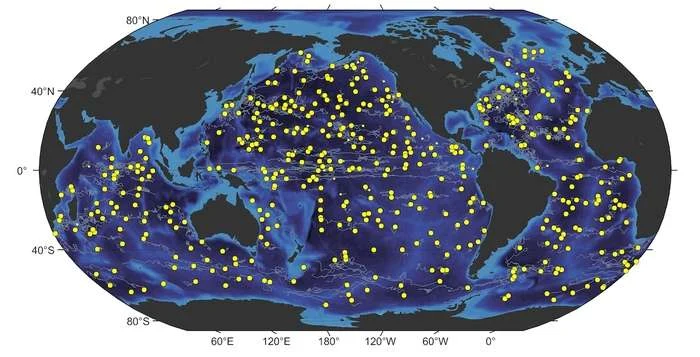
The Global Ocean Biogeochemistry Array (GO-BGC)—a collaborative initiative led by MBARI scientists Ken Johnson and Yui Takeshita and funded by the US National Science Foundation—collects real-time data on ocean health using a global network of hundreds of robotic biogeochemical Argo floats. Scientists have been monitoring data from GO-BGC floats deployed in the equatorial Pacific to track the developing El Niño.
In late September, GO-BGC float data revealed an increase in water temperature, alongside a decrease in concentrations of dissolved carbon dioxide and nitrate, a chemical signature indicating weakened equatorial upwelling. Both are telltale signs of a strengthening El Niño.
The ecological impacts were quickly evident. The equatorial Pacific is typically a region of high plankton productivity, but GO-BGC floats have already logged a sharp decline in chlorophyll concentrations, an indicator of phytoplankton biomass.
“The GO-BGC floats show ecosystem properties before El Niño, in the event, and after, allowing a direct assessment of ocean change. Short-term climate oscillations like El Niño can be a harbinger of longer-term ocean change. These observations will improve our ability to forecast the future,” said Johnson.
Monitoring Monterey Bay
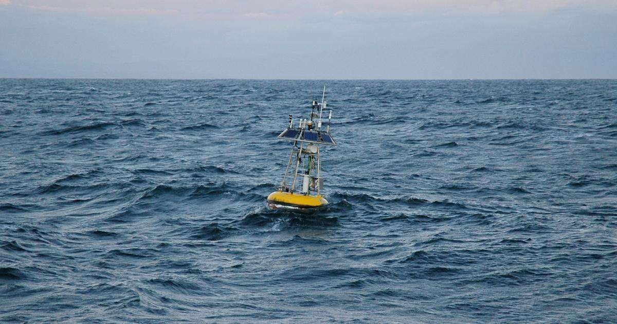
MBARI’s moorings in Monterey Bay have been continuously collecting oceanographic data in Monterey Bay since the early 1990s as part of the long-term Monterey Bay Time Series. The M1 mooring is an important monitoring station located in the center of the bay. This mooring is tethered to an anchor on the seafloor at the mouth of the Monterey Canyon, approximately 1,100 meters (3,600 feet) underwater.

Attached to the M1 buoy and along the cable from the surface to a depth of 300 meters (984 feet) are various scientific instruments that measure environmental conditions such as conductivity (salinity), temperature, depth, oxygen, chlorophyll, and currents. Instruments on the surface buoy gather meteorological data, including solar radiance, wind, pressure, and air temperature. These scientific data are collected around the clock and are made available online.
MBARI scientists have been closely monitoring the development of El Niño in the equatorial Pacific, looking for signs of its arrival in California.
Last week, Senior Scientist Francisco Chavez and MBARI’s Biological Oceanography Group recorded an anomalous warming at depth, a definitive signature of the arrival of El Niño. The temperature at 60 meters (approximately 200 feet), the depth of the thermocline that marks the transition from the ocean’s surface to its depths, has been steadily rising. As of October 26, the temperature reached 18.18 degrees Celsius (64.72 degrees Fahrenheit), surpassing the time series record high set on November 19, 1997, during a previous El Niño event.
“This current El Niño has been forecasted to be one of the strongest of the modern record and the M1 mooring confirms this forecast for Monterey Bay,” said Chavez. “Our data show temperatures more than seven degrees centigrade over the long-term average. This warming has raised sea level by 16 centimeters, or about six-and-a-quarter inches.”
MBARI scientists are closely monitoring daily temperature logs from the M1 mooring to see if the warming trend continues to intensify. Data from the M1 mooring and other MBARI monitoring stations will provide vital context for ecological observations in the months ahead.
The deepening of the thermocline pushes nutrient-rich water below the depth of upwelling, lowering ocean productivity. El Niño brings the warmest water to Monterey Bay during the winter, when ocean productivity is already low, but the effects linger for several months. The strongest biological impacts of El Niño will occur in the spring.
The First Harbingers of Change in Marine Life
Already, MBARI scientists have logged sightings of warm-water species that are rarely seen offshore of Central California.
While conducting blue-water scuba diving operations just west of Davidson Seamount during a recent expedition aboard MBARI’s flagship research vessel David Packard, Senior Scientist Steven Haddock and members of the Biodiversity and Biooptics Team observed a winged comb jelly (Ocyropsis sp.) and a rose siphonophore (Athorybia rosacea), both species that live in tropical waters. During recent maintenance at the M1 buoy, MBARI divers reported schools of halfmoon fish (Medialuna californiensis), a species more commonly found in Southern California.
“Our team has been sequencing the genomes of ctenophores from a variety of ocean environments. Typically, we collect tropical species like Ocyropsis while diving near Hawaii. Finding large reproductive individuals right in our own backyard was a real surprise,” said Haddock.
The influx of warmer water impacts marine life and ecosystems. Species accustomed to cooler water typically retreat northward, often causing cascading effects on the ocean food web. Seabirds are especially vulnerable to shifting food supplies, while whales find their habitat and feeding grounds compressed near the coast.
From the Surface to the Deep
The impacts of El Niño are not limited to the ocean’s surface.
Senior Scientist Bruce Robison and the Midwater Ecology Team have studied the midwater community in Monterey Bay for more than 30 years. Using MBARI’s remotely operated vehicles and, now, autonomous robots, they have collected a trove of animal observations in this expansive habitat between the ocean’s surface and seafloor.
MBARI’s Midwater Time Series allows researchers and collaborators to observe seasonal patterns in community composition, but also observe changes over larger timescales. This and other time series projects at MBARI are vital resources for revealing the impacts of El Niño in Monterey Bay.
During a recent expedition aboard the research vessel David Packard, the team encountered several species that are not often seen in Monterey Bay.
Using MBARI’s remotely operated vehicle Doc Ricketts, the team observed several juvenile pelagic red crabs (Grimothea planipes). While MBARI has observed adult pelagic red crabs in Monterey Bay, we have never seen juveniles this far north.
The expedition team also caught a quick glimpse of several Humboldt squid (Dosidicus gigas). Historically, the distribution of this large, powerful predator has been centered in the warm, eastern equatorial Pacific. Occasionally, the squid population expands, spreading poleward along the coasts of both North and South America, often associated with El Niño events. In the past, their arrival has decimated populations of commercially important species like Pacific hake (Merluccius productus) and restructured the pelagic food web in Monterey Bay.
“As a rule, these warm-water species are uncommon here in the cool depths of Monterey Bay. These sightings are likely the first indicators of a transition in deep midwater community composition and structure, linked to the impending El Niño,” said Robison.
MBARI was part of a 30-year study that monitored the abyssal seafloor offshore of Central California. This research found that El Niño influences communities 4,000 meters (roughly 2.5 miles) underwater.
Marine snow, sinking bits of dead plankton, poop, and other organic material, is a critical food supply for the deep seafloor. El Niño-driven changes in ocean productivity at the surface eventually ripple to the depths below. MBARI researchers have already begun deploying instruments to study how the 2026–2027 El Niño will affect deep-sea communities.
Sharing Data
The ocean plays a vital role in our daily lives. El Niño has significant societal impacts, not just along the California coast, but across the globe. Resource managers and policymakers require robust data about El Niño to make informed decisions about fisheries, coastal flooding hazards, and more.
MBARI researchers are mobilizing to gather data about the ecological impacts of El Niño on Monterey Bay and across Central California. MBARI is committed to sharing its research, technology, data, and expertise with decision-makers.
The Central and Northern California Ocean Observing System (CeNCOOS) is a research collaboration housed at MBARI that provides the information and expertise needed to sustain ocean health. CeNCOOS has partnered with the Southern California Coastal Ocean Observing System and the Integrated Ocean Observing System (IOOS) to launch a new El Niño dashboard aggregating data from researchers and organizations across California.
“CeNCOOS partners have expertise across physics, biogeochemistry, and biology from the Humboldt area south to Morro Bay. Our network brings together data from moorings, gliders, and other technologies along our coast, giving Californians a real-time view of how this El Niño is unfolding along our coast. These data can help fishing communities, coastal planners, and public agencies understand, manage, and mitigate the impact of this historic El Niño,” said CeNCOOS Director Henry Ruhl.
“MBARI’s sustained investment in ocean observing has provided invaluable insight into ocean health for more than 30 years. Time series data allow us to detect anomalies against the backdrop of natural variations. Our innovative technology will continue to monitor the strengthening El Niño, providing the data that scientists urgently need to understand how this natural phenomenon is enhanced by the ongoing warming of the Pacific. MBARI will increase our research activities to assess impacts on marine life and ecosystems, contributing the information that coastal communities and economies need to know,” said MBARI President and CEO Antje Boetius.
MBARI’s research on El Niño is made possible thanks to the longtime support of the David and Lucile Packard Foundation.