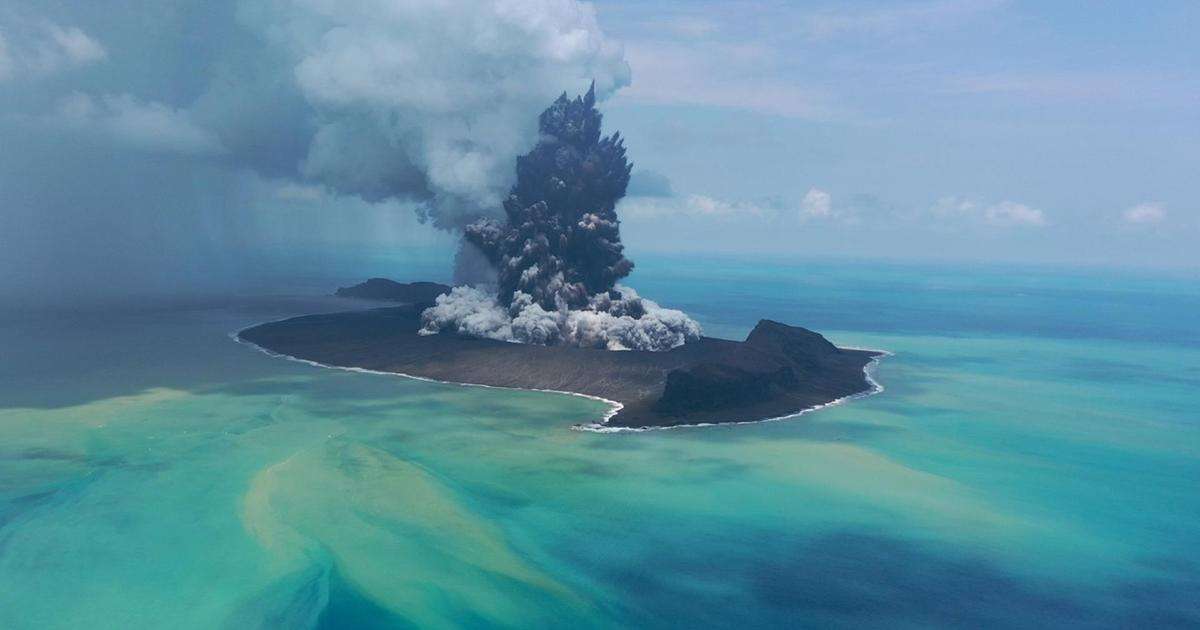
An international research team, including scientists from the National Oceanography Centre (NOC), has published a paper in Nature Geoscience that gives rare insight into the impact of the rapid submarine caldera collapse and could help improve monitoring and early-warning systems for volcanic tsunamis.

The 2022 Hunga volcano eruption triggered deadly volcanic-tsunamis, global atmospheric pressure waves, and delivered huge volumes of volcanic material into the ocean creating fast and destructive underwater flows which caused extensive damage to subsea telecommunications cables.
Using high-resolution bathymetric surveys and water column observations, the research team quantified the changes to the seafloor and calculated the total volume of material displaced during the eruption, revealing that Hunga volcano caldera deepened from 150 m to 850 m below sea level. The total displaced volume of volcanic material was 8.9 cubic kilometers, equivalent to the volume of 1,500 Great Pyramids or 89,000 modern aircraft carriers.
“Hunga gave us an extraordinary opportunity to see just how dramatically the seafloor can change during a major volcanic eruption. It is rare to have detailed maps of the seafloor from before a hazardous event. The unique datasets used in this study allow us to reconstruct what happened during the most explosive volcanic eruption this century, helping us better understand how these processes generate devastating marine hazards, like tsunamis.
“Most submarine volcanoes are still very poorly mapped and monitored. Building repeat observations of these volcanoes is vital if we are to better understand the hazards they pose to coastal communities and critical seafloor infrastructure,” said Dr. Isobel Yeo, senior volcanologist at NOC and co-author of the study.
“There are at least 74 submarine volcanoes along the Tonga–Kermadec Arc, with 20 caldera complexes. Yet, despite the hazards they pose, they are not well-understood as they remain unexplored,” said Dr. Marta Ribó from the Auckland University of Technology (AUT) and lead author of the study.
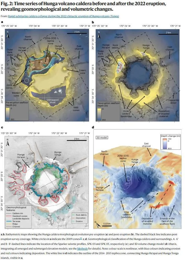
Most of this material was displaced due to the collapse of the caldera, with the rest being surface erosion caused by eruption-fed currents. Despite the massive displacement, the material comprised less than 30 percent of the magma reservoir.
These types of submerged and volcanic-island calderas are associated with some of the largest and deadliest eruptions on Earth, including the 1883 eruption of Krakatau, Indonesia, which killed more than 30,000 people and caused widespread devastation due to resultant pyroclastic density currents and tsunamis.
Due to the steepness of the caldera and the speed of the caldera collapse, the January 15, 2022 Hunga volcano eruption produced an even larger tsunami than Krakatau, with waves about 40 m high at distances up to 100 km away from the source. Despite local devastation, fortunately few lives were lost.
“Seafloor mapping before and after submarine volcanoes eruptions is very rare. Despite their recognized threat, most submarine caldera volcanoes remain unmapped. The bathymetric time-series of Hunga, before and after the 2022 eruption allowed us to better understand processes governing submarine caldera formation, caldera collapse dynamics and associated hazards such as tsunamis or dense underwater flows.”
The 2022 eruption event exposed a critical gap in global preparedness for submarine volcanic hazards.
“Our findings underscore the urgent need for high-resolution repeat seafloor mapping to capture the dynamics of submarine caldera formation and collapse. These time-series datasets are essential for improving submarine volcano hazard monitoring, strengthening tsunami early-warning systems and protecting critical seafloor infrastructure, particularly in poorly surveyed regions such as the southwest Pacific,” said Dr. Marta Ribó from the Auckland University of Technology (AUT) and lead author of the study.
The Nature Geoscience paper was led by AUT’s Dr. Ribó and in association with 22 collaborators across different research institutions from Tonga, New Zealand, the Republic of Korea, the USA, and the UK. NOC co-authors Isobel Yeo and Mike Clare acknowledge funding from NERC under grant NE/X00239X/1 that supported the rapid response investigation.
Read the paper here: https://www.nature.com/articles/s41561-026-02099-7
Read more about Natural Hazards research at NOC: Natural Hazards | National Oceanography Centre